


Drone Aerial Photography — Aerial 3D Visualisations
- During the planning phase of new developments, allowing the planning office to get a very good idea of what a proposed development would look like (and how it would impact on the surrounding landscape) once completed;
- For estate agents, allowing them to market as-yet-unfinished properties using highly realistic imagery of the completed projects — after all, would you to put down a substantial deposit on a house which hasn’t been finished by looking at a photo of a building site? How about having seen multiple photo-realistic computer-generated images showing what the finished house will look like?
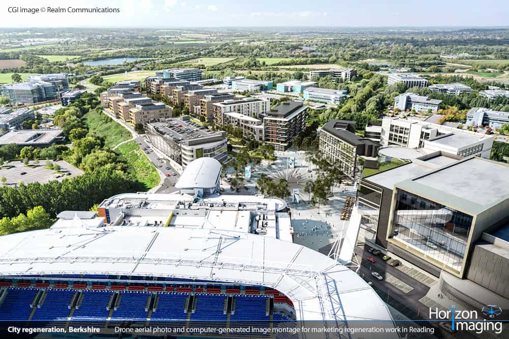
ROLLOVER TO SEE BEFORE / AFTER PHOTOS Before and after marketing photographs of a large potential development site in Reading, Berkshire, next to the Madejski Stadium. CGI image © Realm Communications
Over the last few years we’ve worked with a number of specialist 3D Visualisation Studios who have commissioned us to take drone aerial photographs of their clients’ projects, often from very specific altitudes and angles, which they will then use as the backgrounds for their computer-generated imagery. These projects are briefly outlined below.
Madejski Stadium regeneration proposal, Reading, Berkshire
ROLLOVER TO SEE BEFORE / AFTER PHOTOS Before and after marketing photographs of a large potential development site in Reading, Berkshire, next to the Madejski Stadium. CGI image © Realm Communications
ROLLOVER TO SEE BEFORE / AFTER PHOTOS Before and after marketing photographs of a large potential development site in Reading, Berkshire, next to the Madejski Stadium. CGI image © Realm Communications
Private property marketing imagery, West Sussex
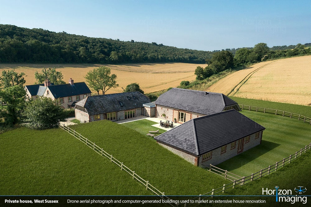
So far we’ve worked on three projects in West Sussex where two property developers and a private individual wanted to produce marketing imagery for their properties so they could be sold before the construction work was completed. For the first two projects we worked with 3D Visualisation firm JA3D, and instead of being told what angles to take, we were simply told to take the most aesthetically-pleasing photographs of the properties in question, and they would did the rest — adjusting and lighting their 3D models to fit seamlessly into the aerial photographs. For the third project, we supplied the aerial photographs directly to the property developer, and they then worked with a 3D Visualisation company to produce the finished marketing imagery.
ROLLOVER TO SEE BEFORE / AFTER PHOTOS Before and after marketing photographs of a brand-new house in East Harting, West Sussex
ROLLOVER TO SEE BEFORE / AFTER PHOTOS Before and after marketing photographs of an extensive house renovation near Treyford, West Sussex
ROLLOVER TO SEE BEFORE / AFTER PHOTOS Before and after marketing photographs of a new housing development near Chichester, West Sussex
Proposed supermarket in Hersham, Surrey
This project involved taking some very high-level aerial photographs of a proposed development site in Hersham, Surrey for Columbian-based 3D Visualisation firm MONOMO. Because the site in question was in the middle of a very congested residential area, we had to fly a fair distance from the site and use a longer focal-length lens to ensure the images we captured contained sufficient detail. The first angle shown below was taken whilst flying over the fields of a Pick-Your-Own farm, and the second angle was taken whilst flying over a complex of office buildings — in both cases permission had to be granted by the respective landowners in order to fly the drone from their land.
ROLLOVER TO SEE BEFORE / AFTER PHOTOS Before and after marketing photographs of a proposed supermarket in Hersham, Surrey
ROLLOVER TO SEE BEFORE / AFTER PHOTOS Before and after marketing photographs of a proposed supermarket in Hersham, Surrey
Over the years we’ve been very fortunate to work with some excellent 3D Visualisation studios who have kindly shared their experiences of working with us in the testimonials below.


Do you work in the property or planning industries? Do you wish there was a way to realistically illustrate how a completed development will look from the air before construction work has commenced? We have many years of experience working with property developers and 3D Visualisation Studios to do just this, and computer simulation software has become so advanced that it’s almost impossible to tell where reality ends and the computer models start. Want to know more? Drop us a line today and we’d be happy to talk through the process with you.